What Is GeoAI — and Why Does It Matter?
“By now, humanity has wrapped the planet in sensors, from the smartphones in our pockets to the satellites circling the globe, generating spatial data at a previously unimaginable scale — and the capacity to make sense of it all is still catching up. GeoAI is here to help to close that gap.”
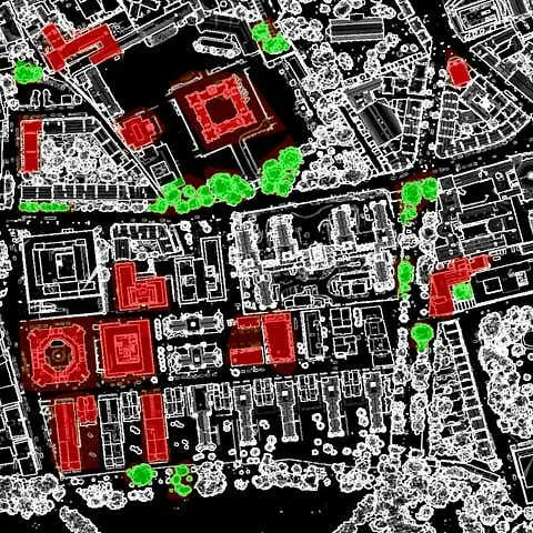
Since my recent official entry to GeoAI (see more here), I wanted to share my thoughts on the bigger picture. Here they are.
Every meaningful event in human life happens somewhere. Floods devastate specific coastlines. Crops fail in particular fields. Diseases spread through defined corridors. Infrastructure crumbles at precise coordinates. For decades, GIS gave analysts the tools to map these realities - but making sense of them still depended entirely on human expertise working through data manually, at human speed. The emergence of artificial intelligence - and deep learning in particular - has fundamentally changed what is possible.
The Core Idea
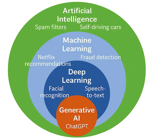
GeoAI - Geospatial Artificial Intelligence - is the integration of AI and spatial analysis. Before going further, it helps to briefly distinguish the terms. Artificial intelligence is the broad field of building systems capable of performing tasks requiring human-like reasoning. Machine learning is a subset of AI in which systems learn from data rather than explicit rules. Deep learning is a further subset using multi-layered neural networks capable of learning highly complex patterns, and it is deep learning that has most dramatically transformed geospatial analysis in recent years. This hierarchy of concepts is also shown in the version of this popular diagram.
Traditional GIS required human experts to define rules, classify features, and draw boundaries. GeoAI teaches machines to do this — and then goes further, discovering spatial patterns that human analysts would most likely not find in time, or at scale. That said, high-quality training data is fundamentally human work: without careful labeling, validation, and domain expertise, even the most sophisticated model produces unreliable results. GeoAI does not replace GIS analysts — it elevates them, freeing them from repetitive manual tasks and placing them where their expertise matters most.
What Makes Spatial Data Special
We can stick AI to any term, making it the most generic buzzword ever. Why should we still say GeoAI? Well, working with geographic data is not the same as working with ordinary tabular data. Spatial data comes in fundamentally different forms — satellite imagery, LiDAR point clouds, GPS traces, aerial photography, and vector geometries — each requiring specialized techniques. Three core concepts govern how AI must handle spatial data differently:
Spatial autocorrelation. Things that are close together tend to be more alike than things far apart. A field adjacent to a crop is more likely to also be a crop than a field ten kilometers away. AI models trained on geographic data must account for this dependency, or their predictions will be unreliable. This also means a model trained on European agricultural fields may fail badly when applied in Southeast Asia — the spatial relationships and landscape patterns simply differ.
Scale and resolution. Geospatial data spans an extraordinary range of resolutions. Synthetic Aperture Radar (SAR) and multispectral satellite imagery typically operate in the range of meters per pixel, while aerial photography can reach centimeters per pixel — a difference of two or three orders of magnitude. Methods that work at one scale routinely fail at another, and GeoAI systems must be designed with their target resolution explicitly in mind.
Temporal dynamics. The same location looks different in April than in July. A building that stood last year may be rubble today. GeoAI increasingly works not just with where things are, but with how they change over time. This makes the appropriate quantity and recency of training data critical — models may still run on outdated data, but accuracy can deteriorate rapidly and silently.
The Technical Toolkit
The dominant programming environment for GeoAI is Python, with deep learning frameworks — primarily PyTorch and TensorFlow — providing the neural network infrastructure. Geospatial libraries such as GDAL, Rasterio, GeoPandas, and Shapely handle data ingestion and spatial operations. Cloud platforms increasingly provide access to petabyte-scale satellite archives through APIs, removing the need for local data storage.
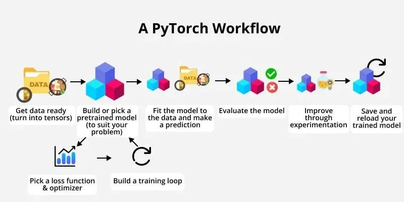
Image source: https://www.learnpytorch.io/01_pytorch_workflow/
At the architectural level, GeoAI draws on a range of deep learning approaches. Rather than treating classical spatial analysis as separate, modern GeoAI typically integrates traditional indices and features — vegetation indices, elevation derivatives, texture measures — directly into neural network pipelines as input channels, giving models physically meaningful starting points rather than raw pixel values alone.
The core deep learning architectures in current use include:
Convolutional Neural Networks (CNNs) — the foundation of most image-based GeoAI. CNNs learn spatial filters that detect edges, textures, and shapes at multiple scales, forming the building blocks of more complex architectures. The U-Net, an encoder-decoder CNN originally developed for medical segmentation, has become the workhorse of pixel-wise geospatial classification tasks such as building extraction and crop mapping.
Transformers — originally developed for natural language, Vision Transformers (ViTs) are increasingly applied to remote sensing imagery, capturing long-range spatial dependencies that convolutional approaches can miss.
Graph Neural Networks (GNNs) — where data has an inherent network structure (road networks, drainage basins, urban connectivity), GNNs model spatial relationships between connected entities directly.
Generative Adversarial Networks (GANs) — used for image super-resolution, synthetic training data generation, and filling gaps in satellite time series caused by cloud cover.
Siamese Networks — paired architectures that compare two inputs, well-suited to change detection between satellite images captured at different times.
Knowledge Graphs — encode geographic relationships and semantic context, enabling AI systems to reason about spatial entities rather than just classify pixels.
And more.
What GeoAI Can Do
The applications span virtually every sector where location matters — which is nearly every sector.
Environmental monitoring. GeoAI systems track deforestation in near real-time, map urban heat islands from aerial thermal data, monitor coastal erosion, and detect illegal mining from satellite imagery. Models trained on multi-temporal data can identify vegetation loss within days of it occurring.
Agriculture. Crop mapping at the national scale — classifying what is growing where across millions of hectares — was once a years-long manual exercise. Deep learning models applied to satellite time series can now accomplish this in hours, using the same technology to support precision irrigation, yield forecasting, and early pest detection.
Urban analysis. Building footprint extraction, road network mapping, informal settlement detection, rooftop solar potential assessment — GeoAI has demonstrated performance that exceeds manual digitization, at a fraction of the time and cost. One U.S. county used GeoAI to inventory thousands of ADA-compliant curb ramps in days rather than months.
Disaster response. After earthquakes, floods, or conflict, GeoAI systems process satellite and drone imagery to automatically identify damaged structures and displaced populations. The UN World Food Programme has used drone mapping combined with AI to locate flood victims in areas inaccessible to responders on the ground.
Public health. Spatial epidemiology — understanding where disease spreads and why — has long been a discipline within GIS. GeoAI extends this by incorporating predictive models that leverage mobility data, environmental conditions, and population vulnerability to forecast outbreak trajectories before they unfold.
... and many more!
The Challenges That Remain
These same strengths come with real limitations — and the field is candid about them.
Data quality and bias. Models are only as good as their training data. Geographic datasets are often incomplete, inconsistent across regions, or systematically biased toward well-resourced areas. A building segmentation model trained on European aerial imagery may perform poorly in an African city where building materials, roof shapes, and street patterns differ fundamentally. This is where human expertise remains irreplaceable.
Spatial generalization. A model trained on one geographic region routinely degrades when applied to another. How to build models that generalize across landscapes, climates, and spatial contexts remains one of the defining unsolved problems in GeoAI. Spatial cross-validation, domain adaptation, and transfer learning are active research areas addressing this.
Explainability. When a deep learning model classifies a field as cropland or flags a building as damaged, it is often unclear why. In high-stakes domains — disaster response, infrastructure planning, public health — unexplainable predictions are a liability. Explainable AI (XAI) methods adapted for geospatial data are a growing research priority.
Ethics and privacy. GeoAI systems can track human movement at scale, identify vulnerable populations, and make consequential resource allocation decisions. Data privacy, algorithmic fairness, and governance of planetary-scale systems are not peripheral concerns — they are central to whether GeoAI serves humanity broadly or reinforces existing inequalities.
Where the Field Is Heading
In my perspective, these are some of the most converging directions define the current frontier today, in early 2026:
Foundation models for Earth observation — large pre-trained models analogous to GPT, fine-tuned for geospatial tasks — are beginning to emerge, promising to dramatically reduce the labeled data required for new applications.
Digital twins — high-fidelity simulations of cities, ecosystems, and infrastructure networks — are becoming practical tools for urban planning and climate adaptation, enabling policymakers to test interventions before implementing them.
Multi-modal fusion — combining satellite imagery, LiDAR, radar, social media, sensor networks, and administrative data into unified AI frameworks — produces richer situational awareness than any single data source permits.
Natural language interfaces — LLM-powered chatbots are beginning to translate plain-language queries directly into spatial analysis workflows, making GeoAI accessible to users without programming or GIS backgrounds.
The Bigger Picture
Geography has always been about understanding the relationship between the physical world and human activity. GeoAI does not change that mission — moreover, it radically expands the tools available to pursue it.
By now, humanity has wrapped the planet in sensors, from the smartphones in our pockets to the satellites circling the globe, generating spatial data at a previously unimaginable scale — and the capacity to make sense of it all is still catching up. GeoAI is here to help to close that gap.
